Redis是如何实现 “附近的人”功能的?
来源:饿了么物流团队
https://juejin.im/post/5da40462f265da5baf410a11
操作命令
GEOADD: 将给定的位置对象(纬度、经度、名字)添加到指定的key;
GEOPOS: 从key里面返回所有给定位置对象的位置(经度和纬度);
GEODIST: 返回两个给定位置之间的距离; GEOHASH: 返回一个或多个位置对象的Geohash表示;
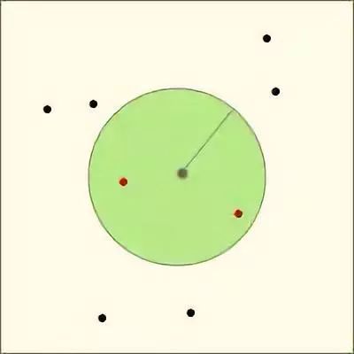
GEORADIUS: 以给定的经纬度为中心,返回目标集合中与中心的距离不超过给定最大距离的所有位置对象; GEORADIUSBYMEMBER: 以给定的位置对象为中心,返回与其距离不超过给定最大距离的所有位置对象。
以下会从源码角度入手对GEOADD和GEORADIUS命令进行分析,剖析其算法原理。
Redis geo操作中只包含了“增”和“查”的操作,并没有专门的“删除”命令。主要是因为Redis内部使用有序集合(zset)保存位置对象,可用zrem进行删除。
在Redis源码geo.c的文件注释中,只说明了该文件为GEOADD、GEORADIUS和GEORADIUSBYMEMBER的实现文件(其实在也实现了另三个命令)。从侧面看出其他三个命令为辅助命令。
GEOADD
使用方式
GEOADD key longitude latitude member [longitude latitude member ...]
(integer) N
源码分析
/* GEOADD key long lat name [long2 lat2 name2 ... longN latN nameN] */
void geoaddCommand(client *c) {

//参数校验
    /* Check arguments number for sanity. */
    if ((c->argc - 2) % 3 != 0) {
        /* Need an odd number of arguments if we got this far... */
        addReplyError(c, "syntax error. Try GEOADD key [x1] [y1] [name1] "
                         "[x2] [y2] [name2] ... ");
          return;
    }

//参数提取Redis
    int elements = (c->argc - 2) / 3;
    int argc = 2+elements*2; /* ZADD key score ele ... */
    robj **argv = zcalloc(argc*sizeof(robj*));
    argv[0] = createRawStringObject("zadd",4);
    argv[1] = c->argv[1]; /* key */
    incrRefCount(argv[1]);

//参数遍历+转换
    /* Create the argument vector to call ZADD in order to add all
     * the score,value pairs to the requested zset, where score is actually
     * an encoded version of lat,long. */
    int i;
    for (i = 0; i < elements; i++) {
        double xy[2];

    //提取经纬度
        if (extractLongLatOrReply(c, (c->argv+2)+(i*3),xy) == C_ERR) {
            for (i = 0; i < argc; i++)
                if (argv[i]) decrRefCount(argv[i]);
            zfree(argv);
            return;
        }

    //将经纬度转换为52位的geohash作为分值 & 提取对象名称
        /* Turn the coordinates into the score of the element. */
        GeoHashBits hash;
        geohashEncodeWGS84(xy[0], xy[1], GEO_STEP_MAX, &hash);
        GeoHashFix52Bits bits = geohashAlign52Bits(hash);
        robj *score = createObject(OBJ_STRING, sdsfromlonglong(bits));
        robj *val = c->argv[2 + i * 3 + 2];

    //设置有序集合的对象元素名称和分值
        argv[2+i*2] = score;
        argv[3+i*2] = val;
        incrRefCount(val);
    }

//调用zadd命令,存储转化好的对象
    /* Finally call ZADD that will do the work for us. */
    replaceClientCommandVector(c,argc,argv);
    zaddCommand(c);
}
double类型精度为52位;
geohash是以base32的方式编码,52bits最高可存储10位geohash值,对应地理区域大小为0.6*0.6米的格子。换句话说经Redis geo转换过的位置理论上会有约0.3*1.414=0.424米的误差。
算法小结
1、参数提取和校验;
2、将入参经纬度转换为52位的geohash值(score);
3、调用ZADD命令将member及其对应的score存入集合key中。
GEORADIUS
使用方式
GEORADIUS key longitude latitude radius m|km|ft|mi [WITHCOORD] [WITHDIST] [WITHHASH] [ASC|DESC] [COUNT count] [STORE key] [STORedisT key]
以给定的经纬度为中心,返回目标集合中与中心的距离不超过给定最大距离的所有位置对象。
由于 STORE 和 STORedisT 两个选项的存在,GEORADIUS 和 GEORADIUSBYMEMBER 命令在技术上会被标记为写入命令,从而只会查询(写入)主实例,QPS过高时容易造成主实例读写压力过大。 为解决这个问题,在 Redis 3.2.10 和 Redis 4.0.0 中,分别新增了 GEORADIUS_RO 和 GEORADIUSBYMEMBER_RO两个只读命令。
不过,在实际开发中笔者发现 在java packageRedis.clients.jedis.params.geo的 GeoRadiusParam 参数类中并不包含 STORE 和 STORedisT 两个参数选项,在调用georadius时是否真的只查询了主实例,还是进行了只读封装。感兴趣的朋友可以自己研究下。
["member1","member2","member3"]
[
  ["member1", distance1, [longitude1, latitude1]]
  ["member2", distance2, [longitude2, latitude2]]
]
源码分析
此段源码较长,看不下去的可直接看中文注释,或直接跳到小结部分
/* GEORADIUS key x y radius unit [WITHDIST] [WITHHASH] [WITHCOORD] [ASC|DESC]
 * [COUNT count] [STORE key] [STORedisT key]
 * GEORADIUSBYMEMBER key member radius unit ... options ... */
void georadiusGeneric(client *c, int flags) {
    robj *key = c->argv[1];
    robj *storekey = NULL;
    int stoRedist = 0; /* 0 for STORE, 1 for STORedisT. */

//根据key获取有序集合
    robj *zobj = NULL;
    if ((zobj = lookupKeyReadOrReply(c, key, shared.null[c->resp])) == NULL ||
        checkType(c, zobj, OBJ_ZSET)) {
        return;
    }

//根据用户输入(经纬度/member)确认中心点经纬度
    int base_args;
    double xy[2] = { 0 };
    if (flags & RADIUS_COORDS) {
    ……
    }

//获取查询范围距离
    double radius_meters = 0, conversion = 1;
    if ((radius_meters = extractDistanceOrReply(c, c->argv + base_args - 2,
                                                &conversion)) < 0) {
        return;
    }

//获取可选参数 (withdist、withhash、withcoords、sort、count)
    int withdist = 0, withhash = 0, withcoords = 0;
    int sort = SORT_NONE;
    long long count = 0;
    if (c->argc > base_args) {
        ... ...
    }

//获取 STORE 和 STORedisT 参数
    if (storekey && (withdist || withhash || withcoords)) {
        addReplyError(c,
            "STORE option in GEORADIUS is not compatible with "
            "WITHDIST, WITHHASH and WITHCOORDS options");
        return;
    }

//设定排序
    if (count != 0 && sort == SORT_NONE) sort = SORT_ASC;

//利用中心点和半径计算目标区域范围
    GeoHashRadius georadius =
        geohashGetAreasByRadiusWGS84(xy[0], xy[1], radius_meters);

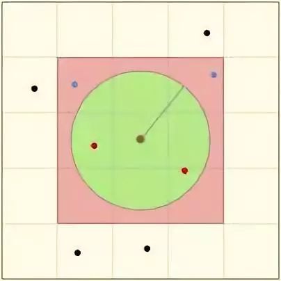
//对中心点及其周围8个geohash网格区域进行查找,找出范围内元素对象
    geoArray *ga = geoArrayCreate();
    membersOfAllNeighbors(zobj, georadius, xy[0], xy[1], radius_meters, ga);

//未匹配返空
    /* If no matching results, the user gets an empty reply. */
    if (ga->used == 0 && storekey == NULL) {
        addReplyNull(c);
        geoArrayFree(ga);
        return;
    }

//一些返回值的设定和返回
    ……
    geoArrayFree(ga);
}
geohashGetAreasByRadiusWGS84和membersOfAllNeighbors两个函数。计算中心点范围:
GeoHashRadius geohashGetAreasByRadiusWGS84(double longitude, double latitude,
                                           double radius_meters) {
    return geohashGetAreasByRadius(longitude, latitude, radius_meters);
}

//返回能够覆盖目标区域范围的9个geohashBox
GeoHashRadius geohashGetAreasByRadius(double longitude, double latitude, double radius_meters) {
//一些参数设置
    GeoHashRange long_range, lat_range;
    GeoHashRadius radius;
    GeoHashBits hash;
    GeoHashNeighbors neighbors;
    GeoHashArea area;
    double min_lon, max_lon, min_lat, max_lat;
    double bounds[4];
    int steps;

//计算目标区域外接矩形的经纬度范围(目标区域为:以目标经纬度为中心,半径为指定距离的圆)
    geohashBoundingBox(longitude, latitude, radius_meters, bounds);
    min_lon = bounds[0];
    min_lat = bounds[1];
    max_lon = bounds[2];
    max_lat = bounds[3];

//根据目标区域中心点纬度和半径,计算带查询的9个搜索框的geohash精度(位)
//这里用到latitude主要是针对极地的情况对精度进行了一些调整(纬度越高,位数越小)
    steps = geohashEstimateStepsByRadius(radius_meters,latitude);

//设置经纬度最大最小值:-180<=longitude<=180, -85<=latitude<=85
    geohashGetCoordRange(&long_range,&lat_range);

//将待查经纬度按指定精度(steps)编码成geohash值
    geohashEncode(&long_range,&lat_range,longitude,latitude,steps,&hash);

//将geohash值在8个方向上进行扩充,确定周围8个Box(neighbors)
    geohashNeighbors(&hash,&neighbors);

//根据hash值确定area经纬度范围
    geohashDecode(long_range,lat_range,hash,&area);

//一些特殊情况处理
    ……

//构建并返回结果
    radius.hash = hash;
    radius.neighbors = neighbors;
    radius.area = area;
    return radius;
}
对中心点及其周围8个geohash网格区域进行查找:
//在9个hashBox中获取想要的元素
int membersOfAllNeighbors(robj *zobj, GeoHashRadius n, double lon, double lat, double radius, geoArray *ga) {
    GeoHashBits neighbors[9];
    unsigned int i, count = 0, last_processed = 0;
    int debugmsg = 0;

//获取9个搜索hashBox
    neighbors[0] = n.hash;
    ……
    neighbors[8] = n.neighbors.south_west;

//在每个hashBox中搜索目标点
    for (i = 0; i < sizeof(neighbors) / sizeof(*neighbors); i++) {
        if (HASHISZERO(neighbors[i])) {
            if (debugmsg) D("neighbors[%d] is zero",i);
            continue;
        }

  //剔除可能的重复hashBox (搜索半径>5000KM时可能出现)
        if (last_processed &&
            neighbors[i].bits == neighbors[last_processed].bits &&
            neighbors[i].step == neighbors[last_processed].step)
        {
            continue;
        }

  //搜索hashBox中满足条件的对象
        count += membersOfGeoHashBox(zobj, neighbors[i], ga, lon, lat, radius);
        last_processed = i;
    }
    return count;
}


int membersOfGeoHashBox(robj *zobj, GeoHashBits hash, geoArray *ga, double lon, double lat, double radius) {
//获取hashBox内的最大、最小geohash值(52位)
    GeoHashFix52Bits min, max;
    scoresOfGeoHashBox(hash,&min,&max);

//根据最大、最小geohash值筛选zobj集合中满足条件的点
    return geoGetPointsInRange(zobj, min, max, lon, lat, radius, ga);
}


int geoGetPointsInRange(robj *zobj, double min, double max, double lon, double lat, double radius, geoArray *ga) {

//搜索Range的参数边界设置(即9个hashBox其中一个的边界范围)
    zrangespec range = { .min = min, .max = max, .minex = 0, .maxex = 1 };
    size_t origincount = ga->used;
    sds member;

//搜索集合zobj可能有ZIPLIST和SKIPLIST两种编码方式,这里以SKIPLIST为例,逻辑是一样的
    if (zobj->encoding == OBJ_ENCODING_ZIPLIST) {
        ……
    } else if (zobj->encoding == OBJ_ENCODING_SKIPLIST) {
        zset *zs = zobj->ptr;
        zskiplist *zsl = zs->zsl;
        zskiplistNode *ln;

  //获取在hashBox范围内的首个元素(跳表数据结构,效率可比拟于二叉查找树),没有则返0
        if ((ln = zslFirstInRange(zsl, &range)) == NULL) {
            /* Nothing exists starting at our min. No results. */
            return 0;
        }

  //从首个元素开始遍历集合
        while (ln) {
            sds ele = ln->ele;
    //遍历元素超出range范围则break
            /* Abort when the node is no longer in range. */
            if (!zslValueLteMax(ln->score, &range))
                break;
    //元素校验(计算元素与中心点的距离)
            ele = sdsdup(ele);
            if (geoAppendIfWithinRadius(ga,lon,lat,radius,ln->score,ele)
                == C_ERR) sdsfree(ele);
            ln = ln->level[0].forward;
        }
    }
    return ga->used - origincount;
}

int geoAppendIfWithinRadius(geoArray *ga, double lon, double lat, double radius, double score, sds member) {
    double distance, xy[2];

//解码错误, 返回error
    if (!decodeGeohash(score,xy)) return C_ERR; /* Can't decode. */

//最终距离校验(计算球面距离distance看是否小于radius)
    if (!geohashGetDistanceIfInRadiusWGS84(lon,lat, xy[0], xy[1],
                                           radius, &distance))
    {
        return C_ERR;
    }

//构建并返回满足条件的元素
    geoPoint *gp = geoArrayAppend(ga);
    gp->longitude = xy[0];
    gp->latitude = xy[1];
    gp->dist = distance;
    gp->member = member;
    gp->score = score;
    return C_OK;
}
算法小结


算法分析


更多好文章
评论
