
通过 Java 技术手段,获取女朋友定位地址...
👇👇关注后回复 “进群” ,拉你进程序员交流群👇👇
作者丨 肥仔哥哥1930
来源:
blog.csdn.net/zwrlj527/article/details/119823407
今早,看到CSDN里推荐的Python获取女朋友发来加班拍照定位地址是酒店的段子,本来准备验证下,顺便练练手的,最后,安装执行pip install json报没有指定版本号。
一怒之下搞我大JAVA,验证可行与场景体遐想。废话不多说,先上硬货。
依赖导入
从博文上看是exifread模块,找我大java的对应的jar,发现metadata-extractor,而且官方还在持续更新,最近的jar是今年的。
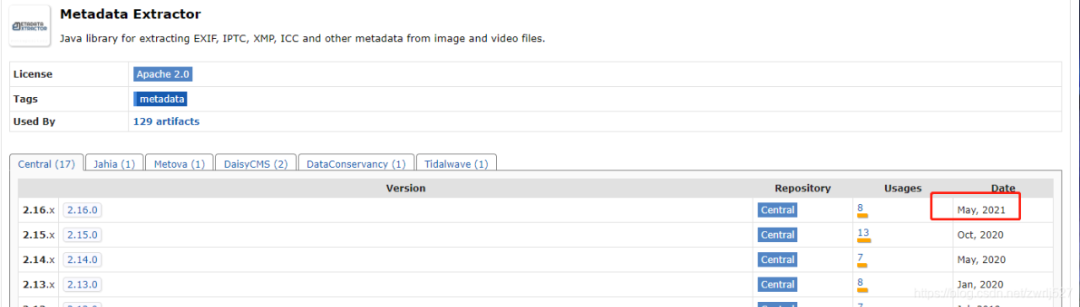
这个元数据提取jar非常强大,还支持视频信息的提取,看看官方介绍:
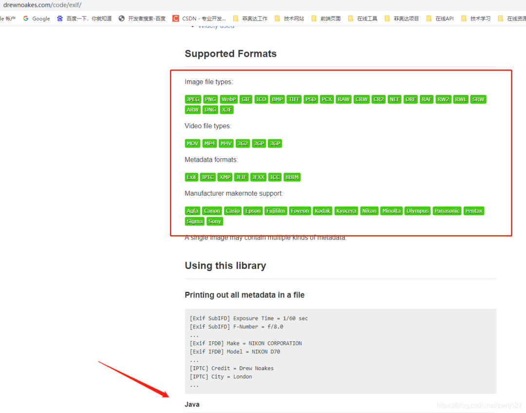
看到没,第一个示例,就写的支持我大JAVA,让我犹如鸡血冲顶,在支持同事联调事件工单的同时,大肝这块。
<dependency><groupId>com.drewnoakes</groupId><artifactId>metadata-extractor</artifactId><version>2.16.0</version></dependency>
准备工作
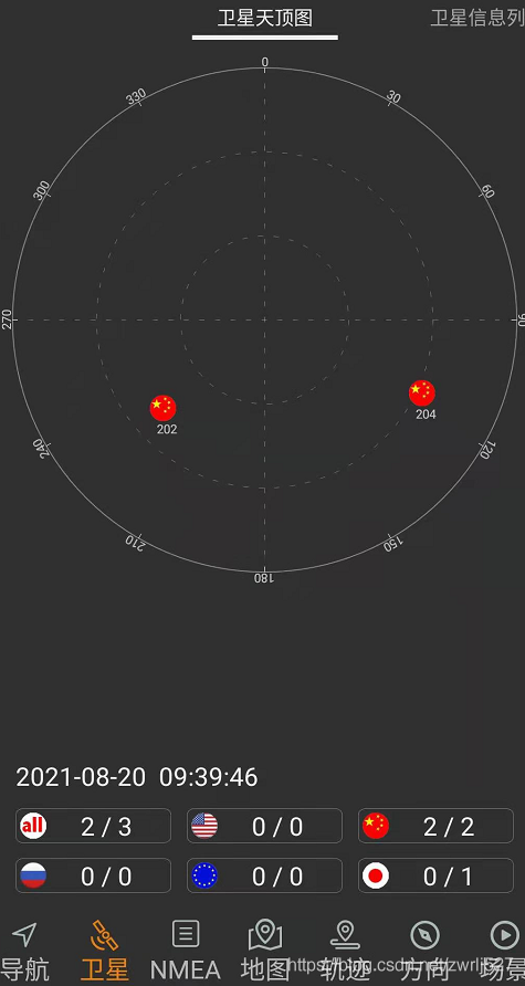
1、室外空旷地点打开GPS
2、百度地图、北斗伴验证已连接到GPS定位
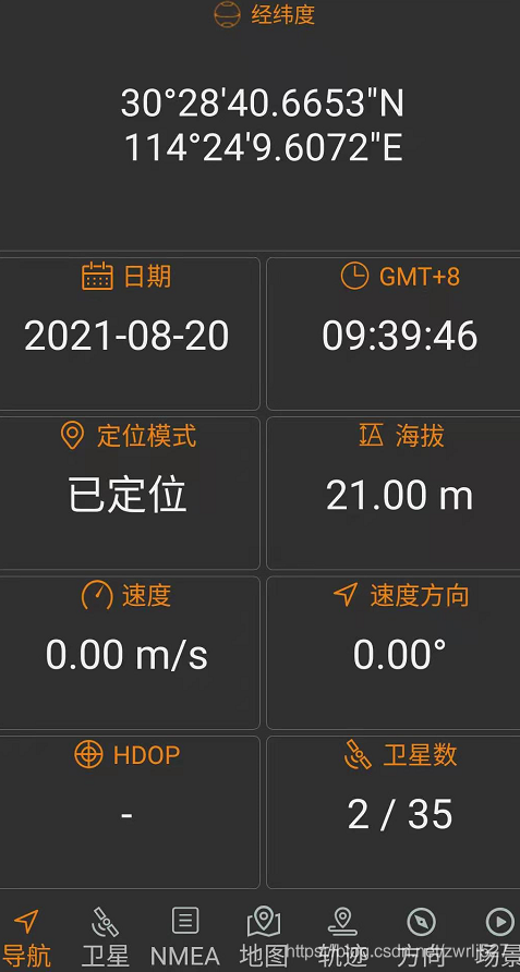
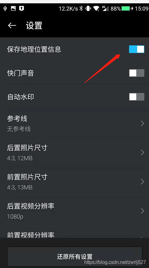
3、设置手机带的照相机开启位置信息
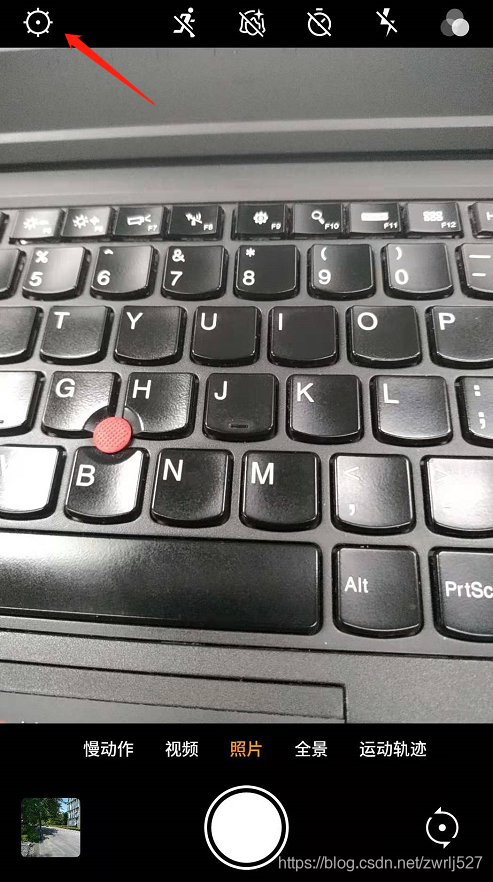
4、拍照一张顺便查看照片详情
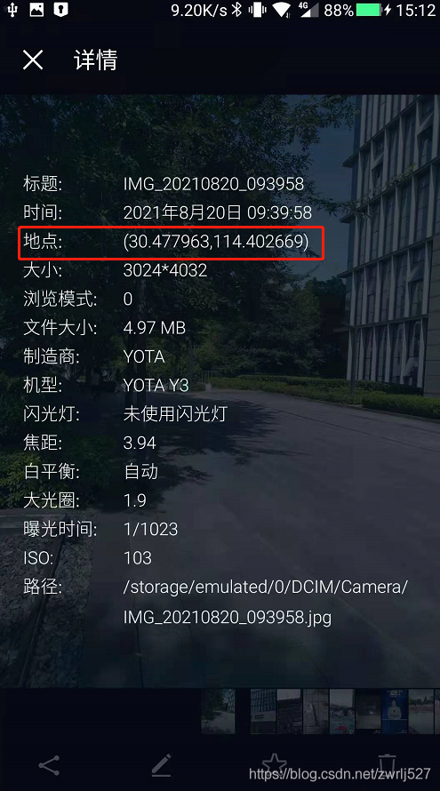
这里一定要确定拍的照片的详情时有经纬度信息的,如果没有,你针对你的手机在CSDN里搜索下怎么设置。这里顺便提下,CSDN的浏览器插件真香。简直就是我们技术人事的福音,再以不用担心某某度的广告之类导致找东西费劲了,而且它很包容,还时可以选择自己喜欢的搜索引擎的。
示例demo
这里先演示这个元数据提取jar能提取到的信息,顺便把取到的经纬度通过百度转地址。
因为是demo,没有业务,我这里就直接在测试类里干了。没有什么业务,不涉及什么机密,可以上全码。
package com.easylinkin.bm.extractor;import com.alibaba.fastjson.JSONObject;import com.drew.imaging.ImageMetadataReader;import com.drew.imaging.ImageProcessingException;import com.drew.metadata.Directory;import com.drew.metadata.Metadata;import com.drew.metadata.Tag;import com.easylinkin.bm.util.HttpUtils;import lombok.extern.slf4j.Slf4j;import java.io.File;import java.io.IOException;/*** @author zhengwen**/@Slf4jpublic class ImgTestCode {public static void main(String[] args) throws Exception {File file = new File("C:\\Users\\zhengwen\\Desktop\\test\\IMG_20210820_093958.jpg");readImageInfo(file);}/*** 提取照片里面的信息** @param file 照片文件* @throws ImageProcessingException* @throws Exception*/private static void readImageInfo(File file) throws ImageProcessingException, Exception {Metadata metadata = ImageMetadataReader.readMetadata(file);System.out.println("---打印全部详情---");for (Directory directory : metadata.getDirectories()) {for (Tag tag : directory.getTags()) {System.out.format("[%s] - %s = %s\n",directory.getName(), tag.getTagName(), tag.getDescription());}if (directory.hasErrors()) {for (String error : directory.getErrors()) {System.err.format("ERROR: %s", error);}}}System.out.println("--打印常用信息---");Double lat = null;Double lng = null;for (Directory directory : metadata.getDirectories()) {for (Tag tag : directory.getTags()) {String tagName = tag.getTagName(); //标签名String desc = tag.getDescription(); //标签信息if (tagName.equals("Image Height")) {System.err.println("图片高度: " + desc);} else if (tagName.equals("Image Width")) {System.err.println("图片宽度: " + desc);} else if (tagName.equals("Date/Time Original")) {System.err.println("拍摄时间: " + desc);} else if (tagName.equals("GPS Latitude")) {System.err.println("纬度 : " + desc);System.err.println("纬度(度分秒格式) : " + pointToLatlong(desc));lat = latLng2Decimal(desc);} else if (tagName.equals("GPS Longitude")) {System.err.println("经度: " + desc);System.err.println("经度(度分秒格式): " + pointToLatlong(desc));lng = latLng2Decimal(desc);}}}System.err.println("--经纬度转地址--");//经纬度转地主使用百度apiconvertGpsToLoaction(lat, lng);}/*** 经纬度格式 转换为 度分秒格式 ,如果需要的话可以调用该方法进行转换** @param point 坐标点* @return*/public static String pointToLatlong(String point) {Double du = Double.parseDouble(point.substring(0, point.indexOf("°")).trim());Double fen = Double.parseDouble(point.substring(point.indexOf("°") + 1, point.indexOf("'")).trim());Double miao = Double.parseDouble(point.substring(point.indexOf("'") + 1, point.indexOf("\"")).trim());Double duStr = du + fen / 60 + miao / 60 / 60;return duStr.toString();}/**** 经纬度坐标格式转换(* °转十进制格式)* @param gps*/public static double latLng2Decimal(String gps) {String a = gps.split("°")[0].replace(" ", "");String b = gps.split("°")[1].split("'")[0].replace(" ", "");String c = gps.split("°")[1].split("'")[1].replace(" ", "").replace("\"", "");double gps_dou = Double.parseDouble(a) + Double.parseDouble(b) / 60 + Double.parseDouble(c) / 60 / 60;return gps_dou;}/*** api_key:注册的百度api的key* coords:经纬度坐标* http://api.map.baidu.com/reverse_geocoding/v3/?ak="+api_key+"&output=json&coordtype=wgs84ll&location="+coords* <p>* 经纬度转地址信息** @param gps_latitude 维度* @param gps_longitude 精度*/private static void convertGpsToLoaction(double gps_latitude, double gps_longitude) throws IOException {String apiKey = "YNxcSCAphFvuPD4LwcgWXwC3SEZZc7Ra";String res = "";String url = "http://api.map.baidu.com/reverse_geocoding/v3/?ak=" + apiKey + "&output=json&coordtype=wgs84ll&location=" + (gps_latitude + "," + gps_longitude);System.err.println("【url】" + url);res = HttpUtils.httpGet(url);JSONObject object = JSONObject.parseObject(res);if (object.containsKey("result")) {JSONObject result = object.getJSONObject("result");if (result.containsKey("addressComponent")) {JSONObject address = object.getJSONObject("result").getJSONObject("addressComponent");System.err.println("拍摄地点:" + address.get("country") + " " + address.get("province") + " " + address.get("city") + " " + address.get("district") + " "+ address.get("street") + " " + result.get("formatted_address") + " " + result.get("business"));}}}}
控制台打印:
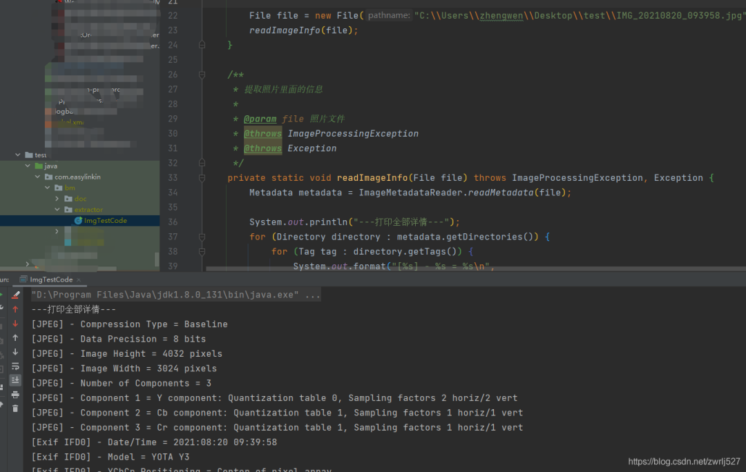
下面贴出详细内容:
com.easylinkin.bm.extractor.ImgTestCode---打印全部详情---[JPEG] - Compression Type = Baseline[JPEG] - Data Precision = 8 bits[JPEG] - Image Height = 4032 pixels[JPEG] - Image Width = 3024 pixels[JPEG] - Number of Components = 3[JPEG] - Component 1 = Y component: Quantization table 0, Sampling factors 2 horiz/2 vert[JPEG] - Component 2 = Cb component: Quantization table 1, Sampling factors 1 horiz/1 vert[JPEG] - Component 3 = Cr component: Quantization table 1, Sampling factors 1 horiz/1 vert[Exif IFD0] - Date/Time = 2021:08:20 09:39:58[Exif IFD0] - Model = YOTA Y3[Exif IFD0] - YCbCr Positioning = Center of pixel array[Exif IFD0] - Resolution Unit = Inch[Exif IFD0] - Y Resolution = 72 dots per inch[Exif IFD0] - X Resolution = 72 dots per inch[Exif IFD0] - Make = YOTA[GPS] - GPS Date Stamp = 2021:08:20[GPS] - GPS Altitude Ref = Below sea level[GPS] - GPS Longitude Ref = E[GPS] - GPS Longitude = 114° 24' 9.61"[GPS] - GPS Processing Method = ASCII[GPS] - GPS Latitude Ref = N[GPS] - GPS Time-Stamp = 01:39:46.000 UTC[GPS] - GPS Altitude = 21 metres[GPS] - GPS Latitude = 30° 28' 40.67"[Exif SubIFD] - Color Space = sRGB[Exif SubIFD] - F-Number = f/1.9[Exif SubIFD] - Date/Time Digitized = 2021:08:20 09:39:58[Exif SubIFD] - Focal Length = 3.9 mm[Exif SubIFD] - Aperture Value = f/1.9[Exif SubIFD] - Exposure Mode = Auto exposure[Exif SubIFD] - Sub-Sec Time Digitized = 819350[Exif SubIFD] - Exif Image Height = 4032 pixels[Exif SubIFD] - Focal Length 35 = 23 mm[Exif SubIFD] - Scene Capture Type = Standard[Exif SubIFD] - Sub-Sec Time Original = 819350[Exif SubIFD] - Exposure Program = Unknown (0)[Exif SubIFD] - White Balance Mode = Auto white balance[Exif SubIFD] - Exif Image Width = 3024 pixels[Exif SubIFD] - Sub-Sec Time = 819350[Exif SubIFD] - Shutter Speed Value = 1/1022 sec[Exif SubIFD] - Metering Mode = Center weighted average[Exif SubIFD] - Date/Time Original = 2021:08:20 09:39:58[Exif SubIFD] - Components Configuration = YCbCr[Exif SubIFD] - Exif Version = 2.20[Exif SubIFD] - Flash = Flash did not fire[Exif SubIFD] - Brightness Value = 0.0[Exif SubIFD] - ISO Speed Ratings = 103[Exif SubIFD] - Sensing Method = One-chip color area sensor[Exif SubIFD] - FlashPix Version = 1.00[Exif SubIFD] - Exposure Time = 1/1023 sec[Interoperability] - Interoperability Index = Recommended Exif Interoperability Rules (ExifR98)[Interoperability] - Interoperability Version = 1.00[Exif Thumbnail] - Y Resolution = 72 dots per inch[Exif Thumbnail] - Thumbnail Length = 21538 bytes[Exif Thumbnail] - Thumbnail Offset = 959 bytes[Exif Thumbnail] - Compression = JPEG (old-style)[Exif Thumbnail] - Resolution Unit = Inch[Exif Thumbnail] - X Resolution = 72 dots per inch[Huffman] - Number of Tables = 4 Huffman tables[File Type] - Detected File Type Name = JPEG[File Type] - Detected File Type Long Name = Joint Photographic Experts Group[File Type] - Detected MIME Type = image/jpeg[File Type] - Expected File Name Extension = jpg[File] - File Name = IMG_20210820_093958.jpg[File] - File Size = 5215044 bytes[File] - File Modified Date = 星期五 八月 20 09:39:59 +08:00 2021--打印常用信息---初始化HttpClientTest~~~开始图片高度: 4032 pixels图片宽度: 3024 pixels经度: 114° 24' 9.61"经度(度分秒格式): 114.40266944444446纬度 : 30° 28' 40.67"纬度(度分秒格式) : 30.477963888888887拍摄时间: 2021:08:20 09:39:58--经纬度转地址--【url】http://api.map.baidu.com/reverse_geocoding/v3/?ak=YNxcSCAphFvuPD4LwcgWXwC3SEZZc7Ra&output=json&coordtype=wgs84ll&location=30.477963888888887,114.40266944444446初始化HttpClientTest~~~结束拍摄地点:中国 湖北省 武汉市 洪山区 软件园路 湖北省武汉市洪山区软件园路9 关山,光谷天地
上面的提取到的内容我就不解释了,应该看得懂,不懂的,可以翻译英文,或者查API看打印的是啥。
其他文件我就不演示了,有兴趣的可以自己试试。
我的百度地图的AK就先放这里,方便大家验证,免得说我骗人,反正我也是免费用的。
最后再说一句,图片发送要么压缩到压缩包再发送,要么用数据线从手机里拷出来。我这里先用微信发的,基本上信息都被抹除了(在电脑上查看图片详情,其实也可以看到经纬度信息的)。
还有,我还有个苹果手机,其实也是可以拍有地理位置信息的照片的,要打开隐私里的定位,授权照相机。
总结与衍生想法
这个怎么说呢,还是很不错的。用到我们的工作中的话,我们觉得可以替代我们之前做的一个打点巡检的,到达巡检位置拍张照片再配合机器码,不怕你让别人代拍照片了。还有考勤的公出单、外勤等等。
另外还想到这出门在外爱拍照的娃们,你们的照片放到云存储上,然后如果有无良服务商,基本可以把你的轨迹通过你上传的照片时间绘制出来。。。
好了,这个就分享到这里。这里其实还给我一个最大的感受就是,如果我不知道A就不会想到B。要是我早知道图片可以携带的信息,或者知道照相机软件可以获取的信息,可能可以针对这些早点做点什么。
————————————————
版权声明:本文为CSDN博主「肥仔哥哥1930」的原创文章,遵循CC 4.0 BY-SA版权协议,转载请附上原文出处链接及本声明。
原文链接:https://blog.csdn.net/zwrlj527/article/details/119823407/
-End-
最近有一些小伙伴,让我帮忙找一些 面试题 资料,于是我翻遍了收藏的 5T 资料后,汇总整理出来,可以说是程序员面试必备!所有资料都整理到网盘了,欢迎下载!
点击👆卡片,关注后回复【
面试题】即可获取评论